Sunday, March 31, 2013

Photo & Video Series: Whiskey Gulch


@ the top of Family Wall via the "Grumpy Old Men" V1 Route  


Looking out to the Tobacco Roots

Spire Rock on the left, Whiskey Gulch on the right

MT Highway 2 west from Whitehall


Reuben on the Senile Boulder topping out "Deltoids of Doom" V4 route


Driving through Whiskey Gulch

Temporarily Stuck in snow melt, mud & muck. Lots of sticks- works every time.
Climbing bruises

Friday, March 29, 2013

Climb On....First Day of Sport Climbing


EEEH! My first day of actual climbing!

After ranting about my new-found love of bouldering at work last night, a co-worker suggested that we go out and climb over at Bozeman Pass today. She said her boyfriend had all the gear and that they would be willing to show me the ropes. Score! They picked me up this morning and we headed east on I-90 out of Bozeman into Bozeman Pass, a portion of highway cutting through a chunky spot in the Bridger Mountains connecting Bozeman to the eastern half of the state. At Exit 316 you pull off on the north side of the exit and hike about a mile in to the designated climbing area. The walk was quick but muddy from the melting snow layer that had undoubtedly disintegrated during the previously sunny days but before you knew it we were at the bottom of some sweet looking stone.


We were meeting another group of people, 3 guys and a girl, who were already roped in and climbing at Practice Wall. My group of 3 decided to scramble over to the next section of wall that offered some easier routes that were mostly rated 5.8 & 5.9 with some easy 5.10s. The rock climbing scale for sport climbing is on a 5-point system with 1 & 2 being walking on flat or inclined ground and 3 & 4 encompassing scrambling and light cimbing sections where a rope is not required. From there the scale moves into the 5 category ranging from 5.0-5.15 . The 5-point climbs define bolted-in routes including everything from the easy stuff you mastered at Girl Scout Camp to the super intense Yosemite-type climbs you see online. Today I climbed 4 routes that were in the 5.8-5.9 category with confidence and decent speed!


Since it was my first time climbing with new folks I honestly had no idea what to expect. I wasn't sure if they were going to be sending insanely technical routes that were way out of my league or if they were going to try and find some more simple stuff. I had not been roped in to anything since traversing the high ropes course when I worked for the Girl Scouts in college and that certainly seemed to be a whole other ball game from sport climbing. Not to mention I had already spent every day this week at the bouldering rocks in town so my arms were definitely feeling the strain of pushing my muscles to the limit. Much to my excitement, however, my trips to the bouldering rocks payed off in spades. All four routes that we chose were at a perfect level for a beginner of my level: I haven't climbed much but I am in solid physical condition which sets a great foundation for this type of climbing.


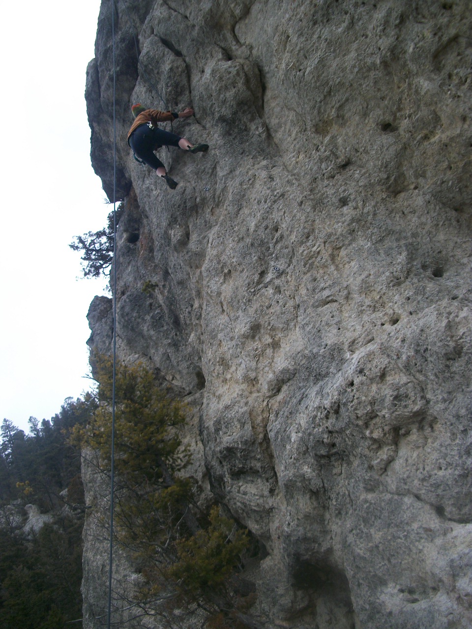
Wendy & Jordan showed me the basic knots, how to clip in and belay up & down, how to set up a rappel from the top. They clued me in to climbing terms like "beta" and "heel hold", "crux" and "send". I was amazed throughout the entire day at my heightened level of confidence, my seemingly nonexistent fear of heights, and my willingness to trust the ropes and the people belaying me. Not once did I look down and get scared, not once did I reach a point where I thought, "Oh boy, I am in over my head" or "I can't do this". All day long was a continuous flow of "You can do it" and "Yes I can". With every tiny grip or disappearing foothold I just clung harder to the rock and found the energy to pull myself up to the top. When the clouds passed over the sun and the wind blew in hard from the west my fingertips turned to little blocks of ice clutching onto frozen rocks but the intensity pushed me through and I found that next ledge to cling on or that final bump to prop my foot on. When the clouds blew past and the sun came out I leaned into the warm rock and soaked in the energy of the sun and the earth and felt so connected to my surrounding landscape. At the top of every climb I leaned back and up to see the beauty of everything around me that had been momentarily put out of mind while focusing on the climb. At the top you get to have that moment all to yourself to take in the beauty of the mountains and cliffs around you, see the world from a birds eye view, and maybe if you're lucky,  see a bald eagle soaring overhead. After all, it is Montana.


~Mary Lane~
Bozeman, MT 3.29.13


For a more detailed description of the Climbing Scale and Rating System check out these links:
Link 1          

Link 2

Monday, March 25, 2013

the Bozeman Boulder

Ever since my trip to southern Utah in early February I have had the climbing itch. The red-rock climbing playgrounds of the southwest just wet my tongue for more climbing, which meant purchasing some new gear and doing some research about the basics of climbing. My favorite new "toy" is my pair of La Sportiva climbing shoes: they are so amazing! They allow my feet to grip the wall with their firm, slender black rubber soles and give me the ability to rest the weight of my entire body on a ledge a quarter inch thick- its pretty sweet.We have been watching a lot of videos on free climbers, bouldering, and rappelling and have scoured through the amazing selection of climbing books at the Bozeman library also. In addition to educational knowledge, we have been taking every advantage of safe climbing spots as they are in abundance in the Rockies! Our only problem this time of year is waiting for the days above ~45 degrees so that our hands stay limber and able to grasp the rocks.

                                                             This afternoon finally brought some warm temps back to the valley and with the sun shining bright we drove to the "bouldering" rock at Bozeman Pond Park. The bouldering rock appears pretty small and you might think it doesn't have much to offer, but rest assured that this hunk of fake rock has about 15 different sections for you to try in varying levels of difficultly from easy-breezy to woah- how do people do that? At the top you can lay around and catch the impressive view of the Bridgers hanging to the north of town and as soon as your hands rest from your ascent you can climb down a different route and test your skills. Today was very successful and I climbed up 4 of the sections with my spider-like La Sportivas- awesome!

~Mary Lane~
Bozeman, MT 3.25.13

Grabbin' Those Miles...


This past weekend I was determined to get my thirty miles in and with two days & 14 miles left Reuben and I needed to cover some ground. The weather was pretty cold but there were nice spots of sun on Saturday and Sunday and since there was a fresh layer of powder, the trails were practically deserted as everyone else in town headed for the ski hills at Bridger Mountain & Big Sky. 

On Saturday we headed 10 minutes north of town to the Sypes Canyon Trailhead located in a rural neighborhood in the Bridger foothills. The Bridger Mountains flank Bozeman & the Gallatin Valley to the northeast and run about 20 miles north, being characterized by a sharp spine of rock dominating the skyline for miles. Sypes Canyon meanders through the forest gaining 1100 feet of elevation over 2 miles of trail, beginning with a nice climb along a rock escarpment following above Sypes Creek. The trail swings down and follows along the snow covered creek lined with large Ponderosa pines, crimson willow branches, and other unidentifiable dormant plants, sleepy after a long winter. Spring is an interesting time to be hiking in the northern Rockies and it reminds me of winter in the southeast; brown and dry with little patches of snow. Trees and cliff-side that were exposed to the sun during the day were snow-free and warm while the inner canyon was still coated in a two foot-deep layer of snow.

 
The trail continues along and crosses Sypes Creek then follows a series of three long switchbacks that crest at an overlook to the south with expansive views of Bozeman, the Gallatin Valley, the Madison mountains to the west & the Gallatin Mountains bordering Yellowstone National Park. There is a nice bench here and the trail continues along the ridge with a couple of superfluous switchbacks until you are hiking along the spine of the ridge bordering the south side of Sypes Canyon. The trail becomes more snowy here as most people make it no further than the overlook, especially in the winter when the ridge-line provides high exposure to wind. If there is fresh snow you also have the task of establishing the trail by trudging your way through the snow, but if you're lucky and someone has hiked ahead of you, then you have a relatively nice worn down surface for hiking in running shoes or boots. This particular day we happened to be following a long-distance runner who was looping up and down the trail so we were able to follow his tracks while re-enforcing the trail with our own boot-prints. As we hiked further up we were able to see our tracks back along the spine and after another mile or so we reached the junction with the Bridger Foothills Trail that continued 3 & a half miles to the south where it ties in with the College "M" Trail or 20 miles to the north along the spine of the range, ending at Fairy Lake. Cool!


The College "M"  
After having discovered the Bridger Foothills junction, we decided that for Sunday I would run a shuttle so that Reuben could start at the College "M" trail-head and I could drive over to the Sypes Trailhead, hike up to the junction and meet Reuben there. I dropped Reuben off and headed back to Sypes where I was the only car parked on a sunny Bozeman Sunday. I wanted to make quick time up the ridge so that I would be able to rendezvous with Reuben in time for me to make it all the way to the junction. He has a fast pace and was planning on running if possible, so I knew I had to cover my miles fast, and amazingly enough we arrived at the junction within 5 minutes of each-other. We ran most of the way back down, sliding through the snow and tramping down the clear sections of trail. Over the two days I now had my 15 miles and I went into work that night tired and well worn.

~Mary Lane~
Bozeman, MT 3.24.13

Tuesday, March 19, 2013

Weekend Adventure Series: Spire Rock Flats


The sun woke us up this warm Saturday morning and we headed over to the Emerson Center to peruse the local Farmers Market. We stocked up on local-raised sausage and those delicious ginger molasses cookies to accompany us on our weekend journey. Back at the house we began the ritual of grabbing anything deemed necessary for an early season camp-out in Montana: tent & sleeping bags, headlamps & long-johns, food supplies  to include fresh ground PB & Morna's raspberry jam, a block of extra sharp Tillamook, apples, tangerine & pistachios. Yum!
An hour later after a protein-packed breakfast of sausage, egg & potato hash we hit the road and headed west on Interstate 90 through the sunny Gallatin Valley towards the Continental Divide Pass where we hoped to find some good climbing. We did not have a specific destination other than "the rocks at the pass in the Beaverhead- Deerlodge National Forest" but I have been through the area on the interstate so often and noticed the really epic landscape and I looked at some maps before hand so we were sure we would find something entertaining. About 75 miles outside of Bozeman we took Exit 241 for "Pipestone" and followed a road for "Delmoe Lake" because it was clad in that iconic Forest Service brown.

The landscape we passed through was a maze of narrow dirt roads and an old rail-bed zigzagging in and out of the main gravel road. We saw several trailheads but noticed that everything but cars were allowed, meaning off-highway vehicles (OHVs) and that is a big red flag for Reuben and I. Nothing ruins a hike more than getting clouds of dirt and dust blown up into your face every ten minutes. Down that road at the "Four Corners" we acquired a map of the "OHV Pipestone" area we were traveling through, a section of BLM land bordering the forest service and we could see from the map that Delmoe Lake Road meandered 11 miles into the mountains before reaching the lake, which we determined would probably be inaccessible this time of year due to snow. We looked up from the map and from the parking area we could see a small mountain of rocks directly in front of us. We referred to our map and found out that we were looking at Spire Rock Flats- this was exactly what we had been looking for!

We jumped back in the Equinox and drove about a mile over to the base of Spire Rocks, pulled off on a dirt road labeled with a large brown and white arrow and bolted towards the rugged playground ahead of us. It was a beginner climbers paradise, mostly riddled with Class 3 climbing, which is defined as:
"Scrambling or un-roped climbing. You must use your hands most of the time to hold the terrain or find your route.  This may be caused by a combination of steepness and extreme terrain (large rocks or steep snow). Some Class 3 routes are better done with rope." Copyright © 2013 14ers.com®, 14ers Inc.


We spent hours bounding on boulders, crawling up cracks, thrusting our way into crevices & pulling ourselves up and over every rock in our path. We surged forth with a limitless energy and desire for more technical spots and were continually rewarded with pitch after pitch of prime granite to hone our developing climbing skills. I could feel muscles that I had been newly acquainted with pulsing from use and every time I crested a pitch or a boulder I felt like a beast- strong & wild, able to tackle anything in my path. Nearest the top that we were able to reach, we saw a silver box perched high on a ledge, accessible only to those who dared to anchor ropes to the shiny silver bolts lining the Class 4 & 5 walls of granite. From the ledge we saw dozens of birds with a white underbelly that resembled doves or pigeons and made a loud "coo-coo" sound so we figured the box was for research purposes and had been placed by the Fish, Wildlife & Parks crew. The birds above us probably had an even better view than us but nonetheless, as we turned and looked to the south and east we were overwhelmed by the beauty of the Tobacco  Root Mountain capped in snow being reflected on by the sun behind those lofty big sky clouds.


That evening Reuben built a small fire that reminded me of the little fires my dad used to make. We hardly ever build fires anymore, they lose their excitement after years of working at camps and on trail crews, but the temperature was dropping and the warmth and comforting glow added to the authenticity of the moment. We munched on our sausage, cheese, fruit and those delicious ginger cookies then crawled into our cozy Half Dome where my brand new Mojave down sleeping bag kept me nice and toasty through the snowy night. 

~Mary Lane~
Bozeman, MT 3.16.13